
Due to a geomagnetic storm last month, SpaceX lost 40 of its 49 Starlink satellites, an estimated $100MM loss in assets. The geomagnetic storm occurring when the satellites were launched, increased the density of Earth’s ionosphere, resulting in an increased drag coefficient for the SpaceX Starlink satellites, dooming most of the cluster to burn back into the atmosphere.
What is Starlink?
Starlink is a new satellite internet service provider using low Earth orbit satellites. Traditional satellite internet service has been provided by geosynchronous satellites, which as a consequence of their high orbital altitude, have high latency. Since there are relatively few satellites, capacity is limited and services are data capped. Low Earth orbit satellites solve these issues because their low orbital altitude yields low latency and the number of satellites deployed yields a greater capacity, (Starlink Summary: February 2021, Fineman, Michigan Broadband Alliance)

According to SpaceX, “preliminary analysis shows the increased drag at the low altitudes prevented the satellites from leaving safe mode to begin orbit-raising maneuvers, and up to 40 of the satellites will reenter or already have reentered the Earth’s atmosphere.”
Unveiling Ensemble’s Satellite Drag Explorer
“As the sun enters its next Maximum Stage in Solar Cycle 25, the number of solar flares will increase, and many geomagnetic events will pose challenges for SpaceX and other satellite operators attempting to deploy massive satellite constellations to low earth orbit.”
said Oliver Gerland IV, Director of Product & Strategy at Ensemble.
“In response to the increased solar cycle risks faced by the burgeoning space economy, Ensemble recognized the opportunity to rapidly prototype a solution. As pioneers in space weather analytics, we want to showcase the capabilities of Kamodo, the open-source python analysis software suite that we are building in collaboration with NASA CCMC, and deliver a solution that enhances the capabilities of mission planners and satellite operators,” finished Oliver Gerland.
What does Ensemble’s Satellite Drag Explorer do?
Ensemble’s Satellite Drag Explorer helps users understand how a satellite’s orbit and altitude will be impacted by a geomagnetic event. This can be useful information for mission planning, calculating orbital decay, and understanding a satellite’s exposure to the harmful radiation of the Sun.
Access a prototype of the Satellite Drag Explorer by visiting:
http://alpha.drag.ensemblespacelabs.com:1234/
Step 1: Fetch and Display the Orbit
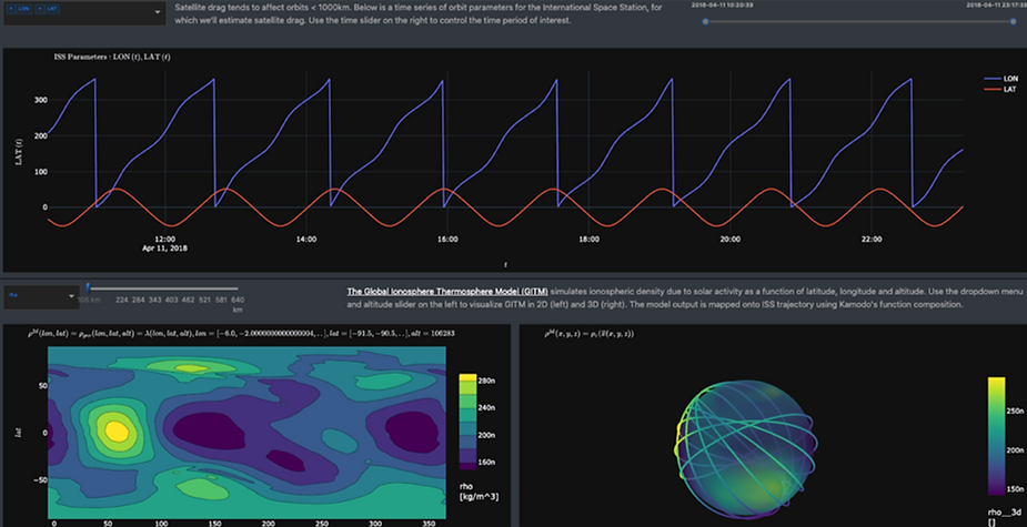
First, Ensemble’s Satellite Drag Explorer fetches the orbit trajectory of the desired satellite. In our demonstration, we fetch and display the orbit of the International Space Station (ISS) which operates in low earth orbit (LEO) around 254 miles (408 kilometers) above earth’s surface. This orbit plot enables users to select and display the longitude, latitude, and altitude for the desired satellite. In the future, many more satellites will be added to the orbit access data library.

Step 2: Fetch and Display the Space Weather Model
Next, Ensemble’s Satellite Drag Explorer fetches and displays the Global Ionosphere Thermosphere Model (GITM). GITM is a 3-dimensional spherical code that models the Earth’s thermosphere and ionosphere system using a stretched grid in latitude and altitude. Users can select the altitude by which the simulation should run, in this case, 408 kilometers to simulate the atmospheric drag experienced by the ISS.

Step 3: Fly Through via Function Composition
Using Kamodo’s function composition and coordinate transformation features, the dashboard integrates the satellite trajectory, flying the orbit through the GITM model. To do this Kamodo performs a coordinate transformation, and visualizes the data on a 3D geocentric sphere.
The functionalization step is accomplished with custom spatio-temporal interpolators, which allows the following function composition to be performed (almost trivially) at a high level:
The selected model parameter rho(lon, lat, alt) is converted from geographic to Cartesian coordinates, rho(x, y, z) through well-known geometric expressions.
Similarly, ISS location is converted from geographic lon(t), lat(t), alt(t) to Cartesian x(t), y(t), z(t)
Finally, the model density is evaluated at rho(x=x(t), y=y(t), z=z(t))
Visualization is accomplished by Kamodo’s automated plotting routines via function inspection: Kamodo generates suitable plotly graphs by analyzing the shapes of data rays coming in and returning from the above functions.

From here, we can visualize and interact with a 3D earth-like object to analyze where in the ISS orbit, the satellite experiences the most intense atmospheric drag. This is highlighted in yellow.
Step 4: Estimate the Satellite’s Loss in Altitude
The drag force is the most dominant force on low-earth orbiting spacecraft and serves to change the energy of the spacecraft through the work done by the drag force. We calculate the local density and velocity of the ISS (left). From these, we compute the drag force (right) to obtain an estimated change in altitude.

This estimated change in altitude is a crucial insight to help satellite operators maintain orbits via station-keeping or help mission planners understand the orbit parameters that can largely avoid the most intense consequences of peak Solar Cycle 25.
Learn more about Ensemble’s Satellite Drag Explorer
Are you a Satellite Operator or Mission Planner interested in a product demo? Check out our page here to sign up for a demonstration of the tool and learn how it can help your next mission planning activities.
https://www.ensembleconsultancy.com/kamodo-1